Work Package 1: Data Compilation and Habitat Mapping
WP1 will compile information on the spatial distribution and temporal variability of physical, chemical and biological properties of the benthic ecosystem through the development of a habitat atlas.
The geo-database will furnish statistical analyses and numerical models of key biogeochemical, physical and ecological processes in relation to state and pressure such as nutrient cycling, pollution, trophic transfer, fishing effort, and circulation.
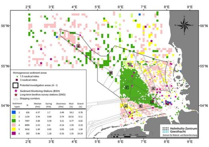
Classification of surface sediments in the German Bight as derived from cluster analysis of different sedimentological parameters. The NOAH focus areas A-I have been identified to represent homogeneous areas for detailed field observations during the project.
Objectives
The overall objective of WP1 is to compile, standardize and manage the NOAH project data within a GIS framework (habitat atlas) and to exploit this database on key biological, chemical and physical properties of the benthic compartment for mapping and classification of habitat types. The sub objectives are:
- To collate the information gathered in all project work packages in a geo-database
- To map habitat types in relation to ecosystem state, services and pressures
- To identify representative sediment provinces for field studies (WP2)
- To provide a web-mapping service for the habitat atlas
- To generate boundary conditions and initial conditions for numerical modeling (WP3)
- To build the database for an integrated, indicator-based assessment carried out in WP4
- To integrate project results into higher-level marine data infrastructures
- To secure archiving and long-term availability of the data
- To publish advances in technical and scientific knowledge
Work Package Leader: Michael Schlüter (AWI), Ingrid Kröncke (Senckenberg am Meer)